easymap-internationale-landkarten

International maps

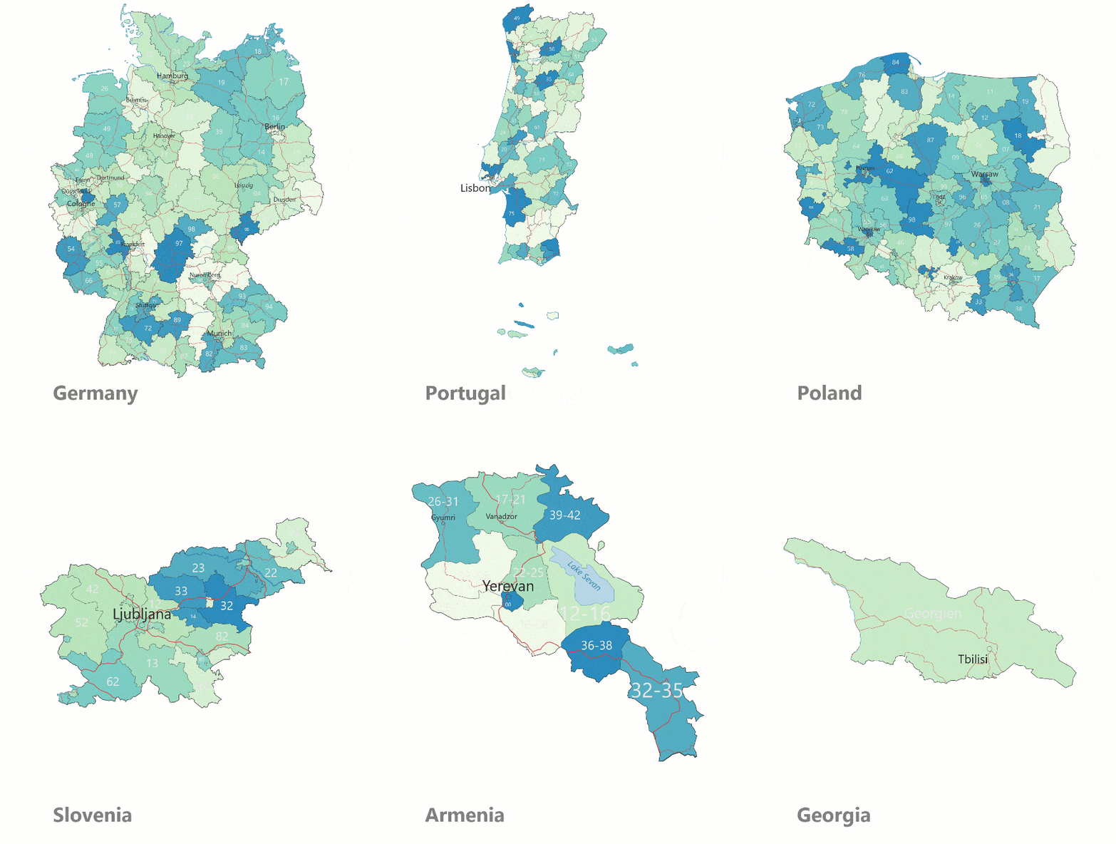
Think beyond borders: For your expansion or to organize your worldwide business, we offer the appropriate international maps. We deliver them in all formats for easymap or your geo-information system, CRM or business intelligence system. Visualize worldwide markets taking into account own or supplier locations, production sites, customer residences.

International zip code maps for the whole world

Nationally and internationally, postal codes play a central role in sales, marketing and controlling. Individual country maps or, for example, the complete Europe package support you in easymap or also in your business intelligence system in preparing data in an even more understandable and transparent way. Our international maps are based on the respective local postal codes of each country. We offer maps of postal routing areas, administrative boundaries as well as detailed road maps for almost every country in the world.

changing cards

Map catalog

For all spatial analyses, an up-to-date and accurate map base is a must. Changes and innovations are taking place at both the postal and administrative levels, which requires regular updating of maps. All of our maps are reviewed and updated annually. In the following, all country maps are listed in their respective outline. On request we offer maps to countries not listed here. The countries marked with a star * are also available as a country package.

  • Albania (4-digit, 2-digit and 1-digit zip code areas)
  • Andorra (5-digit postal code areas)
  • Belarus (4-digit, 2-digit and 1-digit zip code areas)
  • Belgium* Postal code boundaries (4-digit, 2-digit and 1-digit postal code areas)
  • Bosnia and Herzegovina (5-digit, 2-digit and 1-digit zip code areas)
  • Bulgaria* (4-digit, 2-digit and 1-digit zip code areas)
  • Croatia* (5-digit, 2-digit and 1-digit postal code areas)
  • Denmark* (4-digit, 2-digit and 1-digit postal code areas)
  • Estonia* (5-digit, 2-digit and 1-digit postal code areas)
  • Finland (5-digit, 2-digit and 1-digit postal code areas)
  • France* (5-digit, 2-digit and 1-digit postal code areas)
  • Greece* (5-digit, 2-digit and 1-digit postal code areas)
  • Italy* (5-digit, 2-digit and 1-digit postal code areas)
  • Iceland (3-digit, 2-digit and 1-digit zip code areas)
  • Ireland* (3-digit and 1-digit postal code areas)
  • Latvia* (4-digit, 2-digit and 1-digit zip code areas)
  • Lithuania* (5-digit, 2-digit and 1-digit postal code areas)
  • Luxembourg* (4-digit, 2-digit and 1-digit postal code areas)
  • Malta (3-digit postal code areas)
  • Moldova (4-digit and 2-digit zip code areas)
  • Montenegro (5-digit and 2-digit zip code areas)
  • Netherlands* (4-digit, 2-digit and 1-digit postal code areas)
  • North Macedonia (4-digit, 2-digit and 1-digit Postcode Areas)
  • Norway (4-digit, 2-digit and 1-digit postal code areas)
  • Poland* (5-digit, 2-digit and 1-digit postal code areas)
  • Portugal* (4-digit, 2-digit and 1-digit zip code areas)
  • Romania* (2-digit and 1-digit postal code areas)
  • Russia (3-digit, 2-digit and 1-digit postal code areas)
  • Serbia (5-digit, 2-digit and 1-digit zip code areas)
  • Slovakia* (5-digit, 2-digit and 1-digit zip code areas)
  • Slovenia* (4-digit, 2-digit and 1-digit postal code areas)
  • Spain* (5-digit and 2-digit postal code areas)
  • Sweden* (5-digit, 2-digit and 1-digit postal code areas)
  • Czech Republic* (5-digit, 2-digit and 1-digit postal code areas)
  • Turkey (5-digit and 2-digit postal code areas)
  • Ukraine (3-digit and 2-digit postal code areas)
  • Hungary* (4-digit, 2-digit and 1-digit postal code areas)
  • United Kingdom* (5-digit, 4-digit and 2-digit zip code areas)
  • Cyprus (5-digit, 2-digit and 1-digit Postcode areas)
  • Post code boundaries (5 digit, 2 digit and 1 digit zip code areas)
  • Administrative bundaries (Federal states, administrative districts, urban and rural districts, municipalities)
  • Nielsen areas
  • Cities, highways, roads, rivers and lakes
  • Postal boundaries (4-digit, 2-digit and 1-digit postal code areas)
  • Administrative boundaries (states, political districts, municipalities)
  • Cities, highways, roads, rivers and lakes
  • Postal boundaries (4-digit, 2-digit and 1-digit postal code areas)
  • Administrative boundaries (cantons, districts, municipalities)
  • Cities, highways, roads, rivers and lakes
Postleitzahl-Flächen-easymap

Postal codes

Our international maps are based on the respective local postal codes of the individual countries. Nationally and internationally, postal codes play a central role for commercial processes in sales, marketing and controlling. Although many customer contacts take place online today, the zip code logic still offers an established form of territorial division. Postal routing boundaries are available for all countries in the world that maintain a corresponding postal system.

Gemeindeflächen_easymap

Administrative

Administrative (administrative) boundaries are also suitable for a meaningful map representation of regional business contexts. Administrative boundaries are municipal boundaries plus the superordinate county boundaries, government districts and country boundaries. For Switzerland, for example, these are the boundaries for 2162 municipalities, 144 districts and 27 cantons. For all countries worldwide provide fine-grained administrative boundaries.

Raster-Flächen_easymap

Grid

In addition to administrative and postal code boundaries, we also offer boundaries on a microgeographic level. For some use cases, postal and administrative boundaries are not detailed enough, since the area under investigation is much smaller than a postal code area or a municipality. For these small-scale analyses (e.g., customer potential in the immediate vicinity of a supermarket branch), dividing the study area into grid cells is a good option.

Top view: truck parking lot, collage with map

International market data

Would you like to learn even more about the world’s markets? Our international market data shows you where regional purchasing power hotspots are located and potential consumers can be targeted. As an important indicator of consumer behavior, purchasing power is a must when assessing B2C markets. Sociodemographic data such as inhabitants and inhabitants by age group as well as households complete the portfolio and support the identification of relevant target groups.

Button

Easy to test

With the free download of easymap professional, you can convince yourself of the software’s performance easily and without obligation. The full range of functions, including pro features for any test analyses, is available to you for a full 30 days. We will be happy to help you!

Draufsicht Arbeitsplätze Collage mit Karte