Evaluate locations across Europe with international digital maps and market data
Evaluate your European-wide locations with easymap and our international digital maps and market data.
Europe-wide site assessment with raster data
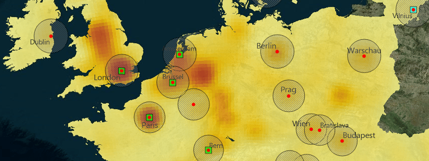
Our pan-European data and maps are suitable for a wide variety of issues. In this example, the branch locations of a company operating across Europe were analyzed. In the first step, the population figures were calculated in a grid of 20 km and then cumulated for a heat map analysis. The regional distribution of the population in Europe is mainly concentrated in the famous Blue Banana, a ribbon-shaped zone extending from Liverpool and Manchester to the north of Italy. In our map, this area is colored red. The concatenation of metropolitan areas around Greater London, Brussels, the Rhine-Ruhr area, the Rhine-Main and Rhine-Neckar regions, through eastern Switzerland to the northern Italian triangle of Turin-Milan-Genoa is clearly visible. Accordingly, the five cities with the highest populations within a radius of 100km are almost all found in the Blue Banana area: London in first place with 22.4 million, followed by Brussels, Paris and Amsterdam. In 5th place, surprisingly, is Bern, ahead of Berlin. Less surprising are the locations with the fewest populations, led by Reykjavik. An accessibility analysis was used to evaluate the store locations. The perimeters around the area locations calculate how many people live within 100 km of the locations. The result is available as an interactive map in easymap explorer. TIPP: The population count of the individual perimeters appears by clicking in the map.
International maps and market data
No matter if you are expanding or already internationally positioned and want to organize your worldwide business even better: We offer the right international maps and market data for your project. These are available in all formats for easymap or your own geo-information system, CRM or business intelligence system.
Postcode maps for the whole world
Visualize worldwide markets taking into account your own or supplier locations, production sites, customer residences. Our international maps are based on the postal codes and administrative boundaries of the respective countries. They are available individually, as country packages or as a complete Europe package. Visit our map catalog for a list of all available country maps. For all spatial analyses, an up-to-date and accurate map base is a must. That’s why we regularly review all our maps and bring them up to date.
International market data
Would you like to learn even more about the world’s markets? In addition to socio-demographic data such as inhabitants, age groups or households, we also offer international data on purchasing power. As an important indicator of consumer behavior, purchasing power is a must when assessing B2C markets. Sociodemographic data such as inhabitants and inhabitants by age group as well as households complete the portfolio and support the identification of relevant target groups. Our international market data supports you in identifying regional purchasing power hotspots and targeting potential consumers. Get informed now!
easymap: The geomarketing solution for Europe
easymap with digital zip code maps and market data for Europe gives you the decisive edge in your international business. Everything from a single source from the long-standing specialists at easymap.
We will advise you and work with you to create a solution tailored to your needs. You can reach our sales department by e-mail at Vertrieb@infas-LT.de or by phone at +49 228 9591490.
This post is also available in: DE


